The toponyms Bedra,
Bidri, Bidar or
Bidare stands for bamboo grove ('bedur' in Tulu; 'bidir' in Kannada). It can be presumed that in early days habitation near bamboo groves were designated as Bedra or Bidare. There is a 'Bidar' town in the northern terminus of Karnataka. And there are two 'Bidare's in Tulunadu known as 'Padubidare' (=Western 'Bidare') and 'Mudubidare' (=Eastern 'Bidare') the two being separated laterally by some 20 kms. The Mudubidare and Padubidare came into prominence because of being historical centres of royal administration by the Tulu kings and chieftains.
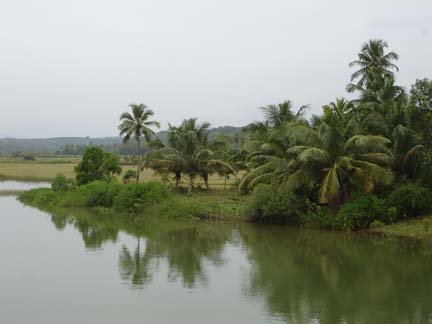
 (Above):The narrow estuary of River Kamini.Padubidri
 is a small town on the coastal NH 17 located between the twin cities of Mangalore and Udupi. The Padubidri-Kuduremukh road connects Karavali towns to Sringeri, Horanadu and other places in Chikmagalur district. Padubidri is well known in the region for annual car festival of Mahalingeshwara Maha Ganapathi Temple and the bi-annual 'Dakke Bali' Naga worship ritual at Brahmasthana, held in odd years , the last ritual was held in 2007 and the next Dakke Bali festival is due to begin during January 2009.

The Padubidri can be developed into a marine Port for handling coal required for the thermal power project that is coming up near Nandikur village. To the east of Padubidri, in the limits Nadisal village is a Special Economic Zone where M/s Suzlon Infrastructure Limited is commissioning a Wind Mill manufacturing facility.
There are a number of interesting places near Padubidri: Hejamadi, Palimar, Nandikur, Balukunje, Ulepadi, Mundkur, Inna, Santhur etc. Some of these places can be discussed in further posts.
Salian PadubidriHosabettu Viswanath drew my attention to an interesting article written by Salian Padubidri of Bangalore ('Mogaveera' March 2006 issue, Kannada) entitled 'Whether West Coast is a creation of a Tsunami?'. The author has discussed some of the perplexing paleo-geographic data gathered around Padubidri under the broad title of creation of West Coast.
Wooden remainsSalian reports that a two inch thick wooden remains associated with black clays were found, while digging for an open-well, at a depth of about 5m (ca.16 ft) below the ground surface in Paduhitlu-Kotiyar area, in the western part of Padubidri. The wooden relics have been considered as remains of a ship that was struck up in the area. The reported site is about two kilometers east of the present coastline and is located in the bed of a partly lost river called 'Kamini'.
Fluctuation of beach-lineApart from the wood, buried sea shells have been reported from sand beds near Yermal, where a keel and anchor of a ship also has been reported. These evidences suggest that the sea coast was further landward in the past and/or an estuary might have been existed in the Yermal coastal area.
The west coast has experienced several phases of transgressions and regressions of the coastline in the past. And one of these regression event has been attributed to the legendary power of the axe of mythological character of Parashurama.
However, all these events should not be mixed up or confused with evidences of a partly lost or mutilated rivulet that was a powerful river once upon a time.
Peat formationSeveral instances of such occurrence of wooden remains have been reported from the region especially around Hejamadi, Yermal, Palimar, Baikampadi and Ullal. While some natives consider the wooden pieces to be the remains of old ships, geologists have identified such material as peat. The peat is a form of ancient decayed wood or plant remains buried in the earth. Peat is the initial product in the process of formation of lignite and coal. The peat in Karavali is usually associated with black clays which occur along the course of several ancient river valleys.
Kamini- Relict of an ancient riverThe available geological data reveal that the Sahyadri ranges (or the Western Ghats) came into being as a result of regional earth movements about 12 to 20 million years ago. At least two generations of rivers can be recognized in the Karavali region: (1)those formed before the rise of Sahyadri ranges and (2) those formed after the rise of Sahyadri ranges.
The earlier pre-Sahyadri generation of rivers were modified or attenuated variably during the rise of Sahyadri ranges. The Kamini river near Padubidri is one example of a pre-Sahyadri river that has shrunken in morphology as a result of earth movements connected with the rise of Sahyadri ranges.
Overall morphology of the relict river appears like a curvy serpent in the topographic map.
Remains of the partly vanished river can still be seen to the north of Padubidri town in the form of broad valley. River Kamini apparently was navigable once upon a time; the streams feeding the river dried up eventually so that now one cannot easily visualize the existence of a bygone full-fledged river. The coastal part of the river still remains appearing more like a inland lake stretching parallel to the beach strip; it joins the Arabian Sea with a curvaceous slender estuary segment near Alive Kodi or the Padubidri 'End point'. The estuary or the river-sea meeting point is so slender,shallow and narrow (about 15 m wide in low tide) that people cross it on foot along the sandy beach to reach adjacent sandy beach strip of Hejmadi. In the lacustrine remains of the former river natives catch sumptuous fishes using throw nets.
Salian Padubidri has referred to this rivulet as 'Kamini' River, reflecting part of the historicity preserved among local people. However many locals are not aware of the name of this rivulet. It is also not known at this juncture whether any reference to this particular Kamini river exists in Tulu historical documents like sthala-purans and paD-danas.
The coast parallel limb of the Kamini river was probably formed some two centuries ago approximately coeval with similar coast-parallel changes in
Gurupur River.
Natural changesWe normally assume that man-made factors like reclaiming of shallow river bed and consequential encroachment and diversion of tributary streams /rivulets for irrigation and socio-political purposes may have contributed to the alteration of original geographies. However the modification and mutilation of Kamini river can be attributed to natural earth movements (especially those events connected with the rise of Sahyadris) that induced drastic changes in the river morphology.
Hosabettu Viswanath recollects witnessing a fatal accident that occurred while he was holidaying in the Karavali during November 1977 on vacation from Pune. An ill-fortuned autorickshaw collided with a rushing express bus on the NH-17 near the culvert north of Padubidri and nose-dived into the watery valley that represents remains of the lost river Kamini.
Viswanath who was on the way though studied the area deeply could not decipher at that pathetic moment that it was the area occupied by the mutilated river. He recalls what Winston Churchill funnily spoke of not discovering the truth sometimes:
'Men occasionally stumble over the truth but most of them pick themselves up as if nothing ever happened”
Reconstructing River KaminiSome outlines of the lost River Kamini can be put together based on the available geologic data. The river was flowing along NNE to SSW direction north of Padubidri town and joining the Arabian Sea approximately north of the present estuary point known as Alive-kodi.
It can be suggested the river took a southward coastal bend possibly during the late 18th century, more or less coinciding with the time-event of the abrupt southward turn of Gurupur River.
Similarly it can be deduced based on circumstantial geological evidences that the peat formations were formed by the decay of plants and woods transported from upland regions along the River Kamini during some 8 to 20 million years ago. This would put the age of River Kamini to that bygone geological period when the Sahyadri ranges were rising slowly upward in response to the tectonic events in the region.
Ackowledgement:
Special thanks to Salian Padubidri for provoking us to look into the antecedents of the River Kamini.
Written with Hosabettu Viswanath.
®