The existence of clustered villages in Karavali has been discussed in earlier posts. Aroor, in Udupi taluk is another cluster village located on the northern banks of River Madisal.It can be approached from the Brahmavara-Pethri road.
Six hamlets namely Kurdunje, Tenkabettu, Belmaru, Adpu, Arjelu and Mel-arjelu together constitute the village known as Aroor (Aar + oor =six hamlets/village).These hamlets were known for six 'MaTas' (religious centres).

A heritage blog by: Ravindra Mundkur & Hosabettu Vishwanatha
Tuesday, January 20, 2009


Monday, January 19, 2009
168. Baindur, Bayandar
Baindur is a coastal town located to the north of Kundapur. The 'Bainda' is an old Kannada variant of the word 'Baidya'. The Baidya were the native doctors or shamans among the ancient Bhil or Billava tribes. The famous Tulu heroes Koti and Chennaya were from the Baidya subcommunity of Billavas. Thus the Baind+oor refers to the village of Baidya or Baidyas.
Bayandar is an equivalent place name in Maharastra. The word 'Bayanda' is an alternate form of Bainda or Baidya. Thus Bayanda+ar refers to the ar (place) of Bainda or Baidya.
ShamBa Joshi has written about the presence of Kannada language and culture in Maharstra region in the historical past. Thus the place name Bayandar is another evidence in favour of the presence of analogous words in Kannada and Maharastra regions.
Bayandar is an equivalent place name in Maharastra. The word 'Bayanda' is an alternate form of Bainda or Baidya. Thus Bayanda+ar refers to the ar (place) of Bainda or Baidya.
ShamBa Joshi has written about the presence of Kannada language and culture in Maharstra region in the historical past. Thus the place name Bayandar is another evidence in favour of the presence of analogous words in Kannada and Maharastra regions.
Saturday, January 17, 2009
167. Padubidri: Relic of an ancient river
The toponyms Bedra, Bidri, Bidar or Bidare stands for bamboo grove ('bedur' in Tulu; 'bidir' in Kannada). It can be presumed that in early days habitation near bamboo groves were designated as Bedra or Bidare. There is a 'Bidar' town in the northern terminus of Karnataka. And there are two 'Bidare's in Tulunadu known as 'Padubidare' (=Western 'Bidare') and 'Mudubidare' (=Eastern 'Bidare') the two being separated laterally by some 20 kms. The Mudubidare and Padubidare came into prominence because of being historical centres of royal administration by the Tulu kings and chieftains.

(Above):The narrow estuary of River Kamini.
Padubidri is a small town on the coastal NH 17 located between the twin cities of Mangalore and Udupi. The Padubidri-Kuduremukh road connects Karavali towns to Sringeri, Horanadu and other places in Chikmagalur district. Padubidri is well known in the region for annual car festival of Mahalingeshwara Maha Ganapathi Temple and the bi-annual 'Dakke Bali' Naga worship ritual at Brahmasthana, held in odd years , the last ritual was held in 2007 and the next Dakke Bali festival is due to begin during January 2009.

The Padubidri can be developed into a marine Port for handling coal required for the thermal power project that is coming up near Nandikur village. To the east of Padubidri, in the limits Nadisal village is a Special Economic Zone where M/s Suzlon Infrastructure Limited is commissioning a Wind Mill manufacturing facility.
There are a number of interesting places near Padubidri: Hejamadi, Palimar, Nandikur, Balukunje, Ulepadi, Mundkur, Inna, Santhur etc. Some of these places can be discussed in further posts.
Salian Padubidri
Hosabettu Viswanath drew my attention to an interesting article written by Salian Padubidri of Bangalore ('Mogaveera' March 2006 issue, Kannada) entitled 'Whether West Coast is a creation of a Tsunami?'. The author has discussed some of the perplexing paleo-geographic data gathered around Padubidri under the broad title of creation of West Coast.
Wooden remains
Salian reports that a two inch thick wooden remains associated with black clays were found, while digging for an open-well, at a depth of about 5m (ca.16 ft) below the ground surface in Paduhitlu-Kotiyar area, in the western part of Padubidri. The wooden relics have been considered as remains of a ship that was struck up in the area. The reported site is about two kilometers east of the present coastline and is located in the bed of a partly lost river called 'Kamini'.
Fluctuation of beach-line
Apart from the wood, buried sea shells have been reported from sand beds near Yermal, where a keel and anchor of a ship also has been reported. These evidences suggest that the sea coast was further landward in the past and/or an estuary might have been existed in the Yermal coastal area.
The west coast has experienced several phases of transgressions and regressions of the coastline in the past. And one of these regression event has been attributed to the legendary power of the axe of mythological character of Parashurama.
However, all these events should not be mixed up or confused with evidences of a partly lost or mutilated rivulet that was a powerful river once upon a time.
Peat formation
Several instances of such occurrence of wooden remains have been reported from the region especially around Hejamadi, Yermal, Palimar, Baikampadi and Ullal. While some natives consider the wooden pieces to be the remains of old ships, geologists have identified such material as peat. The peat is a form of ancient decayed wood or plant remains buried in the earth. Peat is the initial product in the process of formation of lignite and coal. The peat in Karavali is usually associated with black clays which occur along the course of several ancient river valleys.
Kamini- Relict of an ancient river
The available geological data reveal that the Sahyadri ranges (or the Western Ghats) came into being as a result of regional earth movements about 12 to 20 million years ago. At least two generations of rivers can be recognized in the Karavali region: (1)those formed before the rise of Sahyadri ranges and (2) those formed after the rise of Sahyadri ranges.
The earlier pre-Sahyadri generation of rivers were modified or attenuated variably during the rise of Sahyadri ranges. The Kamini river near Padubidri is one example of a pre-Sahyadri river that has shrunken in morphology as a result of earth movements connected with the rise of Sahyadri ranges.
Overall morphology of the relict river appears like a curvy serpent in the topographic map.
Remains of the partly vanished river can still be seen to the north of Padubidri town in the form of broad valley. River Kamini apparently was navigable once upon a time; the streams feeding the river dried up eventually so that now one cannot easily visualize the existence of a bygone full-fledged river. The coastal part of the river still remains appearing more like a inland lake stretching parallel to the beach strip; it joins the Arabian Sea with a curvaceous slender estuary segment near Alive Kodi or the Padubidri 'End point'. The estuary or the river-sea meeting point is so slender,shallow and narrow (about 15 m wide in low tide) that people cross it on foot along the sandy beach to reach adjacent sandy beach strip of Hejmadi. In the lacustrine remains of the former river natives catch sumptuous fishes using throw nets.
Salian Padubidri has referred to this rivulet as 'Kamini' River, reflecting part of the historicity preserved among local people. However many locals are not aware of the name of this rivulet. It is also not known at this juncture whether any reference to this particular Kamini river exists in Tulu historical documents like sthala-purans and paD-danas.
The coast parallel limb of the Kamini river was probably formed some two centuries ago approximately coeval with similar coast-parallel changes in Gurupur River.
Natural changes
We normally assume that man-made factors like reclaiming of shallow river bed and consequential encroachment and diversion of tributary streams /rivulets for irrigation and socio-political purposes may have contributed to the alteration of original geographies. However the modification and mutilation of Kamini river can be attributed to natural earth movements (especially those events connected with the rise of Sahyadris) that induced drastic changes in the river morphology.
Hosabettu Viswanath recollects witnessing a fatal accident that occurred while he was holidaying in the Karavali during November 1977 on vacation from Pune. An ill-fortuned autorickshaw collided with a rushing express bus on the NH-17 near the culvert north of Padubidri and nose-dived into the watery valley that represents remains of the lost river Kamini.
Viswanath who was on the way though studied the area deeply could not decipher at that pathetic moment that it was the area occupied by the mutilated river. He recalls what Winston Churchill funnily spoke of not discovering the truth sometimes:
'Men occasionally stumble over the truth but most of them pick themselves up as if nothing ever happened”
Reconstructing River Kamini
Some outlines of the lost River Kamini can be put together based on the available geologic data. The river was flowing along NNE to SSW direction north of Padubidri town and joining the Arabian Sea approximately north of the present estuary point known as Alive-kodi.
It can be suggested the river took a southward coastal bend possibly during the late 18th century, more or less coinciding with the time-event of the abrupt southward turn of Gurupur River.
Similarly it can be deduced based on circumstantial geological evidences that the peat formations were formed by the decay of plants and woods transported from upland regions along the River Kamini during some 8 to 20 million years ago. This would put the age of River Kamini to that bygone geological period when the Sahyadri ranges were rising slowly upward in response to the tectonic events in the region.
Ackowledgement:
Special thanks to Salian Padubidri for provoking us to look into the antecedents of the River Kamini.
Written with Hosabettu Viswanath.
®

(Above):The narrow estuary of River Kamini.
Padubidri is a small town on the coastal NH 17 located between the twin cities of Mangalore and Udupi. The Padubidri-Kuduremukh road connects Karavali towns to Sringeri, Horanadu and other places in Chikmagalur district. Padubidri is well known in the region for annual car festival of Mahalingeshwara Maha Ganapathi Temple and the bi-annual 'Dakke Bali' Naga worship ritual at Brahmasthana, held in odd years , the last ritual was held in 2007 and the next Dakke Bali festival is due to begin during January 2009.

The Padubidri can be developed into a marine Port for handling coal required for the thermal power project that is coming up near Nandikur village. To the east of Padubidri, in the limits Nadisal village is a Special Economic Zone where M/s Suzlon Infrastructure Limited is commissioning a Wind Mill manufacturing facility.
There are a number of interesting places near Padubidri: Hejamadi, Palimar, Nandikur, Balukunje, Ulepadi, Mundkur, Inna, Santhur etc. Some of these places can be discussed in further posts.
Salian Padubidri
Hosabettu Viswanath drew my attention to an interesting article written by Salian Padubidri of Bangalore ('Mogaveera' March 2006 issue, Kannada) entitled 'Whether West Coast is a creation of a Tsunami?'. The author has discussed some of the perplexing paleo-geographic data gathered around Padubidri under the broad title of creation of West Coast.
Wooden remains
Salian reports that a two inch thick wooden remains associated with black clays were found, while digging for an open-well, at a depth of about 5m (ca.16 ft) below the ground surface in Paduhitlu-Kotiyar area, in the western part of Padubidri. The wooden relics have been considered as remains of a ship that was struck up in the area. The reported site is about two kilometers east of the present coastline and is located in the bed of a partly lost river called 'Kamini'.
Fluctuation of beach-line
Apart from the wood, buried sea shells have been reported from sand beds near Yermal, where a keel and anchor of a ship also has been reported. These evidences suggest that the sea coast was further landward in the past and/or an estuary might have been existed in the Yermal coastal area.
The west coast has experienced several phases of transgressions and regressions of the coastline in the past. And one of these regression event has been attributed to the legendary power of the axe of mythological character of Parashurama.
However, all these events should not be mixed up or confused with evidences of a partly lost or mutilated rivulet that was a powerful river once upon a time.
Peat formation
Several instances of such occurrence of wooden remains have been reported from the region especially around Hejamadi, Yermal, Palimar, Baikampadi and Ullal. While some natives consider the wooden pieces to be the remains of old ships, geologists have identified such material as peat. The peat is a form of ancient decayed wood or plant remains buried in the earth. Peat is the initial product in the process of formation of lignite and coal. The peat in Karavali is usually associated with black clays which occur along the course of several ancient river valleys.
Kamini- Relict of an ancient river
The available geological data reveal that the Sahyadri ranges (or the Western Ghats) came into being as a result of regional earth movements about 12 to 20 million years ago. At least two generations of rivers can be recognized in the Karavali region: (1)those formed before the rise of Sahyadri ranges and (2) those formed after the rise of Sahyadri ranges.
The earlier pre-Sahyadri generation of rivers were modified or attenuated variably during the rise of Sahyadri ranges. The Kamini river near Padubidri is one example of a pre-Sahyadri river that has shrunken in morphology as a result of earth movements connected with the rise of Sahyadri ranges.
Overall morphology of the relict river appears like a curvy serpent in the topographic map.
Remains of the partly vanished river can still be seen to the north of Padubidri town in the form of broad valley. River Kamini apparently was navigable once upon a time; the streams feeding the river dried up eventually so that now one cannot easily visualize the existence of a bygone full-fledged river. The coastal part of the river still remains appearing more like a inland lake stretching parallel to the beach strip; it joins the Arabian Sea with a curvaceous slender estuary segment near Alive Kodi or the Padubidri 'End point'. The estuary or the river-sea meeting point is so slender,shallow and narrow (about 15 m wide in low tide) that people cross it on foot along the sandy beach to reach adjacent sandy beach strip of Hejmadi. In the lacustrine remains of the former river natives catch sumptuous fishes using throw nets.
Salian Padubidri has referred to this rivulet as 'Kamini' River, reflecting part of the historicity preserved among local people. However many locals are not aware of the name of this rivulet. It is also not known at this juncture whether any reference to this particular Kamini river exists in Tulu historical documents like sthala-purans and paD-danas.
The coast parallel limb of the Kamini river was probably formed some two centuries ago approximately coeval with similar coast-parallel changes in Gurupur River.
Natural changes
We normally assume that man-made factors like reclaiming of shallow river bed and consequential encroachment and diversion of tributary streams /rivulets for irrigation and socio-political purposes may have contributed to the alteration of original geographies. However the modification and mutilation of Kamini river can be attributed to natural earth movements (especially those events connected with the rise of Sahyadris) that induced drastic changes in the river morphology.
Hosabettu Viswanath recollects witnessing a fatal accident that occurred while he was holidaying in the Karavali during November 1977 on vacation from Pune. An ill-fortuned autorickshaw collided with a rushing express bus on the NH-17 near the culvert north of Padubidri and nose-dived into the watery valley that represents remains of the lost river Kamini.
Viswanath who was on the way though studied the area deeply could not decipher at that pathetic moment that it was the area occupied by the mutilated river. He recalls what Winston Churchill funnily spoke of not discovering the truth sometimes:
'Men occasionally stumble over the truth but most of them pick themselves up as if nothing ever happened”
Reconstructing River Kamini
Some outlines of the lost River Kamini can be put together based on the available geologic data. The river was flowing along NNE to SSW direction north of Padubidri town and joining the Arabian Sea approximately north of the present estuary point known as Alive-kodi.
It can be suggested the river took a southward coastal bend possibly during the late 18th century, more or less coinciding with the time-event of the abrupt southward turn of Gurupur River.
Similarly it can be deduced based on circumstantial geological evidences that the peat formations were formed by the decay of plants and woods transported from upland regions along the River Kamini during some 8 to 20 million years ago. This would put the age of River Kamini to that bygone geological period when the Sahyadri ranges were rising slowly upward in response to the tectonic events in the region.
Ackowledgement:
Special thanks to Salian Padubidri for provoking us to look into the antecedents of the River Kamini.
Written with Hosabettu Viswanath.
®
Wednesday, January 14, 2009
166.Tulu Onomastics

Onomastics (Nama Vijnana) means ‘study of names in all aspects – personal, place, pet, nicknames, brand, etc. Onomasticians try to answer following questions about given names:
What they mean – their etymology or origin
How they are used in various cultures
Why some are chosen by parents more often than others
‘What is in a name?’ is a Shakespearean quote in ‘Romeo and Juliet’, which is a tragic tale of “star-cross’d lovers”, named Romeo Montague and Juliet Capulet, belonging two warring families. Juliet says,
“What‘s in a name? That which we call a rose
By any other name would smell as sweet”
Here what Juliet emphasizes is that name is an artificial and meaningless convention, and that she loves the person who is called ’Montague’, not the Montague name and not the Montague family. When Romeo drops his family name ‘Montague’, she asks him to deny (his) father and in stead be baptized anew as “Juliet’s lover”. Thus, Shakespeare proves the limitation of the term ‘name’ by suggesting that regardless of what we call it, a rose would smell sweet.
Yet, there is something else to names. It is ‘some quality that makes names the brocade of that apparel.’ It is a kind of language propriety – one of distinction and differentiation. It is chosen, conferred and announced. Names have meanings instead of definitions.
Anthroponomastics
The study of Personal names is called Anthroponomastics. In Tulunadu, until the close of the last Century one has come across odd personal names. Meaning of most of them is funny, contemptuous, and inscrutable. It is a challenging job to decipher the mystery of it, as can be seen in Ancient Proper Names (Post No 127) in this Blog.
Toponymy
Toponymy or Topomastics or the study of Place-names, is one of the principal branches of Onomastics. There are no historical records to understand the meanings of Place-names in Tulunadu. We do not have a glimmer of an idea of their actual history. So we are trying to explore the origin of odd names prevalent in Tulunadu based on fossils of words, spoken by many tribes - known and unknown. Keeping this in mind, Posts No 111 to 152, especially 141.Village Name suffixes and 162.Evolution of Tulu language were written but feed-backs from readers are not forthcoming.
George R. Stewart
The man, who humanized ‘onomastics’ is George R. Stewart. He was an American toponymist, a novelist, and a Professor of English at the University of California, Berkeley. He is a founding Member of American Name Society (ANS), a non-profit Association founded in1951 to promote onomastics both in United States and abroad. It seeks to find out what really is in a name, and to investigate cultural insights, settlement history and linguistic characteristics revealed in names. The Society provides members with several vehicles for the discussion and publication of onomastic theory, view and concepts. There is another Organization, called ‘International Council of Onomastic Sciences (ICOS), represented by scholars. It is a name-research organization on international level and in an inter-disciplinary context.
Tulu Onomastics
Writings on this subject are negligible in Tulu. To enrich Tulu Onomastics, a Society like ANS is desirable, nay required, for collective efforts. It will help our posterity to improve it further. Readers to this Blog are being invited to contribute their knowledge about place names in Tulunadu. But feed-backs are not to the level expected.
Active participation by the readers would greatly invigorate our modest efforts in updating the Tulu Typonyms.
-Hosabettu Viswanath
۞
Friday, December 26, 2008
165.Pangala and Bangla

Geneticists are studying variations in the human genome haplotypes to trace the evolution and migration of human beings across the continents. Similarly the words especially those antique words and place names that have remained with and migrated to different parts of the globe can be employed to trace the human migration trends. In the previous posts I have tried to demonstrate that some of the words like Tulu, Bantu, Mande, Kola, Mangala, Sira, Siri, etc are quite ancient and have migrated with human tribes from the original cradle of human civilization namely the Africa.
The Pangala is one more such place names that can be added to this list of antique words.
Pāngala
Pangala is a village on the northern bank of rivulet Pangala in Udupi Taluk and can be encountered on the coastal NH 17 while travelling from Mangalore to Udupi..The village name Pangala has been cited in specific Tulu paD-danas suggesting the historical significance of this place in the evolution of Tulunadu.
The Tulu Nighantu provides that the word Pangala means a portion or share, possibly suggesting that it could be a segment of land given as a share.
Alternately, the word can be analyzed as pa+ang+ala. The 'angala' (now means, a courtyard) must have been originally an open area ('ang') by the side of a river ('ala') as already discussed in some previous posts. Then “Pāngala” represents an stretch of an area by the riverside. The prefix 'pa-' possibly represents water or river as discussed in some of the previous posts.
Bangala
A word obviously related to Pangala is Bangal(a), Bangla or Bengal. The word is attributed to deltaic region of eastern India where Himalayan River Ganga debouches into the Bay of Bengal. The word Bangla apparently is an equivalent of Pangala with transition of consonants p.> b. The meaning of a riverside or watery land is also applicable to Bengal as is to Pangala.
Global Pangala
A search in the web provides interesting antiquity aspects of Pangala. We find that 'Pangala' villages exist in Angola and Congo regions of Africa. Similarly, Pangala can be found in Srilanka and Indonesia. It seems that the word Pangala has travelled to different regions along with the migrating human tribes in the remote past.
It would be interesting if persons having knowledge of these global Pangala villages explain us the meaning of this word in their present local languages.
®
Monday, December 22, 2008
164. Belthangadi, Uppinangadi..
There are several places in the Karavali known as 'Angadi's. For example Haleanagdi, Hosangadi, Belthangadi, Uppinangadi etc. An 'Angadi' means a shop in current Tulu and in Kannada. If we use that accepted prevalent meaning to these places these cited above would mean Old shop, New shop, White shop and Salt shop! No this in not true in the historical sense. In these words, the phrase 'urban area' or 'town' needs to be replaced instead of the 'shops'. Analysis of the word 'Angadi' suggests that it originally meant an urbanized area where shops situated like a market or bazaar.
Velangani
There are places known as 'Angadi' s in Kerala also, implying that this toponymistic word was prevalent in different parts of the West Coast. Eventhough Angdi as a place-name is rather uncommon in Karnataka mainland, other variants of the word apparently existed around East Coast. For example Velangani ( or Vailankanni) in Tamilnadu suggests that it was Vela+angani, the 'angani' being a regional variant of the 'angadi'.
Angadi
Adi (pronounced 'aDi') means 'the bottom' or 'the foot'. It originally represented the shade under a large tree where early Paleolithic human beings rested, before a culture of construction of huts initiated. The phrase 'maratta aDi, punkyeda aDi'(=shade of a tree, shade of tamarind tree) etc are used even now by the Tulu village folks.
ADi later represented a habitation with passage of time. Further it also represented an unit of measurement like 'aDi' (one foot, equivalent of a footstep).
PāDi (a farm or an area with trees) is derived from aDi. (pa+aDi) Examples include Bellipadi, Bellarpadi, Kukkipadi Ulipadi etc. Similarly māDi (ma+aDi) is also derived from aDi. Examples Hejamadi, Hemmadi etc.
The word 'ang' is a variant of 'anj' or 'anje' representing an open or uncovered area. (Note the word 'angai': ang+kei =open hand or the palm).
The words angar( Naiki language), angari (Naikri language ) and angad (Parji language) mean courtyard or bazaar in ancient Dravidian languages. (See 141. Village name suffixes)
The word 'angar' was an ancient equivalent of 'angadi', the bazaar. The words 'angār' and 'angaDi' (=bazaar or market) (as in Haleanagdi, Uppinangadi, Belthangadi, Hosanagadi Koppalangadi, Murathangadi, Mudarangadi etc) were in turn derived from --anj or -ang.
Therefore the word 'angadi' represented a open shaded area. Trade began in such open areas as seen in rural markets. Since the people met here for trade and other purposes these areas became the initial urban centres.
Mangar
One of the oldest names of Mangalore was Mangar! Since 'angār' is a variant of 'angadi', mangar ma+ang+ār) could represent an ancient market or bazaar on somewhat an elevated ground (ma).
Haleangadi ,Hosangadi
The place name 'Haleangadi' thus means Old market or town. It signifies shifting of the market or township. 'Posangadi'(=new market) in Tulu represents the area where new market was initially. Located.
Apart from the Halenagadi-Posangadi near Mulki, there is a Hosangadi near Siddapur in Kundapura taluk.
Belthangadi
The place name Belthangadi on the way to Dhamasthala originally was Belle-ta- angadi, the market/town of Belle. There are other 'Belle' villages especially in Udupi taluk. The 'Bellar' or 'Vellar' were a fair skinned tribals that settled in various parts of southern India. Bellara Bellari Bellipadi etc (see also 131.Belman to Bellarpadi)
Uppinagadi
Three possibilities can be deduced with regard to the origin of the name Uppinagadi.Possibly the place name evolved through three stages cited below No 3 to 1 with passage of time.
1.People now believe that the place Uppinagadi has association with salt trade. Uppingadi is situated at the confluence of two rivers namely Nethrāvati and Kumārdhāra.
2.Apart from the salt market tag, the Uppinagadi could have been a modification of Uppuna- angadi, the 'uppuna' represents a residing place.
3.The other possibility is that it was Uphe-na- angadi, where the Munda word 'uphe' or 'ubhe' means two or the junction of two rivers.(see posts 52 and 53). The Tulu equivalent name 'Ubār” (ubh+ar) also suggests of the habitation (ār) by the side of 'ubha'(=two; denoting the two rivers). The ancient word 'ubha' seems lost in current Tulu, but note that it has been preserved in the word 'ubaya' which means 'the both' or 'the two' .
Hosabettu Viswanath adds note on the word 'Ubar' (2):
Ubar/Ubaar (2) also means 'high tide' and brackish or salinity.The word is equivalent of 'ubbara'(Kannada) meaning high tide of the sea. Saline soil and land is called 'ubar nela'. The stink emanating from fields, submerged by high tide salt water, is known as 'ubar-moori' in Tulu. So fish caught in rivers or fields in monsoons smell 'ubar-moori'. It is a known fact that marine fish swim upstream along the estuary, during floods in rainy season and hence the Tulu idiom/proverb, "Ubargu badtina/mittarina meenigu abur ijji" (=No respect for the fish, which swims up-stream during high tides, i.e.they are vulnerable since caught easily).
In monsoons, the Gurupur (Palguni) River gets flooded. In turn the 'Bailare', stretching from Posodi (Hosabettu) to Panambur where the Bailare was debauching into the River (prior to construction new Mangalore Harbour), gets flooded. In those days, there were big catch of fishes, normally found in sea water, such as 'Maala', Paare' (Mullet),etc. in nets spread in Bailare, which is a natural course for storm waters.
However it may be noted that there are no evidences of high tide or salinity reaching up to Uppinangadi along the River Nethravati. But it is known that traditionally wood,rice, salt, condiments and other merchandise were being transported along the River Nethravati that connected the Coast and the Ghat uplands.Therefore, the name Tulu 'Ubar' for Uppinangdi could have been derived from (1) open yard (ar) by the side of two rivers(uba) or (2) open yard where salt was stocked for trade(ubar-salt, the product of high tide).
*
Velangani
There are places known as 'Angadi' s in Kerala also, implying that this toponymistic word was prevalent in different parts of the West Coast. Eventhough Angdi as a place-name is rather uncommon in Karnataka mainland, other variants of the word apparently existed around East Coast. For example Velangani ( or Vailankanni) in Tamilnadu suggests that it was Vela+angani, the 'angani' being a regional variant of the 'angadi'.
Angadi
Adi (pronounced 'aDi') means 'the bottom' or 'the foot'. It originally represented the shade under a large tree where early Paleolithic human beings rested, before a culture of construction of huts initiated. The phrase 'maratta aDi, punkyeda aDi'(=shade of a tree, shade of tamarind tree) etc are used even now by the Tulu village folks.
ADi later represented a habitation with passage of time. Further it also represented an unit of measurement like 'aDi' (one foot, equivalent of a footstep).
PāDi (a farm or an area with trees) is derived from aDi. (pa+aDi) Examples include Bellipadi, Bellarpadi, Kukkipadi Ulipadi etc. Similarly māDi (ma+aDi) is also derived from aDi. Examples Hejamadi, Hemmadi etc.
The word 'ang' is a variant of 'anj' or 'anje' representing an open or uncovered area. (Note the word 'angai': ang+kei =open hand or the palm).
The words angar( Naiki language), angari (Naikri language ) and angad (Parji language) mean courtyard or bazaar in ancient Dravidian languages. (See 141. Village name suffixes)
The word 'angar' was an ancient equivalent of 'angadi', the bazaar. The words 'angār' and 'angaDi' (=bazaar or market) (as in Haleanagdi, Uppinangadi, Belthangadi, Hosanagadi Koppalangadi, Murathangadi, Mudarangadi etc) were in turn derived from --anj or -ang.
Therefore the word 'angadi' represented a open shaded area. Trade began in such open areas as seen in rural markets. Since the people met here for trade and other purposes these areas became the initial urban centres.
Mangar
One of the oldest names of Mangalore was Mangar! Since 'angār' is a variant of 'angadi', mangar ma+ang+ār) could represent an ancient market or bazaar on somewhat an elevated ground (ma).
Haleangadi ,Hosangadi
The place name 'Haleangadi' thus means Old market or town. It signifies shifting of the market or township. 'Posangadi'(=new market) in Tulu represents the area where new market was initially. Located.
Apart from the Halenagadi-Posangadi near Mulki, there is a Hosangadi near Siddapur in Kundapura taluk.
Belthangadi
The place name Belthangadi on the way to Dhamasthala originally was Belle-ta- angadi, the market/town of Belle. There are other 'Belle' villages especially in Udupi taluk. The 'Bellar' or 'Vellar' were a fair skinned tribals that settled in various parts of southern India. Bellara Bellari Bellipadi etc (see also 131.Belman to Bellarpadi)
Uppinagadi
Three possibilities can be deduced with regard to the origin of the name Uppinagadi.Possibly the place name evolved through three stages cited below No 3 to 1 with passage of time.
1.People now believe that the place Uppinagadi has association with salt trade. Uppingadi is situated at the confluence of two rivers namely Nethrāvati and Kumārdhāra.
2.Apart from the salt market tag, the Uppinagadi could have been a modification of Uppuna- angadi, the 'uppuna' represents a residing place.
3.The other possibility is that it was Uphe-na- angadi, where the Munda word 'uphe' or 'ubhe' means two or the junction of two rivers.(see posts 52 and 53). The Tulu equivalent name 'Ubār” (ubh+ar) also suggests of the habitation (ār) by the side of 'ubha'(=two; denoting the two rivers). The ancient word 'ubha' seems lost in current Tulu, but note that it has been preserved in the word 'ubaya' which means 'the both' or 'the two' .
Hosabettu Viswanath adds note on the word 'Ubar' (2):
Ubar/Ubaar (2) also means 'high tide' and brackish or salinity.The word is equivalent of 'ubbara'(Kannada) meaning high tide of the sea. Saline soil and land is called 'ubar nela'. The stink emanating from fields, submerged by high tide salt water, is known as 'ubar-moori' in Tulu. So fish caught in rivers or fields in monsoons smell 'ubar-moori'. It is a known fact that marine fish swim upstream along the estuary, during floods in rainy season and hence the Tulu idiom/proverb, "Ubargu badtina/mittarina meenigu abur ijji" (=No respect for the fish, which swims up-stream during high tides, i.e.they are vulnerable since caught easily).
In monsoons, the Gurupur (Palguni) River gets flooded. In turn the 'Bailare', stretching from Posodi (Hosabettu) to Panambur where the Bailare was debauching into the River (prior to construction new Mangalore Harbour), gets flooded. In those days, there were big catch of fishes, normally found in sea water, such as 'Maala', Paare' (Mullet),etc. in nets spread in Bailare, which is a natural course for storm waters.
However it may be noted that there are no evidences of high tide or salinity reaching up to Uppinangadi along the River Nethravati. But it is known that traditionally wood,rice, salt, condiments and other merchandise were being transported along the River Nethravati that connected the Coast and the Ghat uplands.Therefore, the name Tulu 'Ubar' for Uppinangdi could have been derived from (1) open yard (ar) by the side of two rivers(uba) or (2) open yard where salt was stocked for trade(ubar-salt, the product of high tide).
*
Thursday, December 4, 2008
163 Tulu Prefixes and Words
Additional data from Hosabettu Viswanath provides some more material on the aspect of ancient prefixes in Tulu and Dravida languages.
Incidentally, 'Mu' was the name of hypothetical continent that allegedly existed in one of the Earth's oceans but disappeared at the dawn of history. However, this has no connection to our Tulu prefix 'mu'.
Prefix 'mun'
Prefix 'mun' appears as a derivative of the prefix mu.
mun=initial,beginning, frontal,the first etc.
'Mundu'(front); 'mungar :(mun+kar= initial season of rainy clouds) . Munnade (mun+naDe=go forward), 'mungurul' (mun+kurul= locks of hair on the frontal forehead). Munjāv (mun+jav= early time, early morning),
Similarly, the opposite prefix of 'mun' is 'hin' as in 'hingar' (hin+kar =next rainy season, winter rains, also winter crops).
Prefix 'muk' or 'muv'
'Muk/v' means 'three' (mukkal, mukkalige= three legged stool or small chair). Muvver (=three persons)
Prefix 'mei'
Possibly prefix 'me' (pronounced 'mei') =above or upper.
Consider the word 'medale'.
'mei' + tale (head or shoulder)> medale. i.e. end part of sāri taken to back side over the shoulder. .
Apparently the original 'mei' evolved into words like 'mel' (mei+l) = upper or above.
Prefixes 'Pa' and 'pā'
There is a shorter 'pa' prefix besides the 'pā' cited in previous post.
Possibly pa=rocky, pā= water
Panja p' or pa+anja (=rocky land), punja (p'+anja =rocky land)
Pā:(=water,river)
Pāngala pā+angala (land on the bank a river), Pāndi (pā+anDi). pā+ani=water
Bandar:
band+ar Enclosed or protected area, port. The port was a protected area within enclosures to protect goods since the historical days. However the word 'bandar'(=port) is apparently more widely spread.
.
In Maharastra, there is a place called 'Bandra' in the Western suburbs of Mumbai city, which was the centre of power of Portuguese in 16th/17th century before gifting away the Bombay islands to British as marriage gift. The word Bandra appears to be variant of the word bandar, the port. The Bandra is known as 'Vandra/Vandre' in Marathi.Earlier entire parts of the Mahim-Bandra Island was known as 'Salsette' Note the following lines on Bandra as gleaned from a Wikipedia page:
“Bandra is a possible adaptation of Bandar, a Persian word for Port. There are other views on the origin of the name: that it is derived from a Portuguese Princess for one, and another more plausible one that it is a corruption of 'Bandar-gah' in Persian (Bandar is a common word for Port in Iran), which means Port. May be Vandre in Marathi and Bandar in Persian both mean port and come from the same Sanskrit root word. This area was under Shilahar dynasty in 12th Century. It is referred to as 'Bandora' in gravestones in the cemetery of St. Andrews Church and in the writings of Mount Struart Elphinstone of the English East India Co., which describe the endeavours to acquire the island of Salsette”.
Similarities in place names of Maharastra and Tulunadu needs to be studied further.
Prefix 'ban'
The prefix 'ban' (pronounced as bun) stands for forest or wild area and the Sanskrit equivalent of 'van'(forest).[A case of b>v transition;.banga>vanga]
Examples for place names with ban- prefix: Bannanje, Bannadi,Banvasi,
Further, the 'banga-' words as in banga, bangarasu, bangawadi,bangal,bangera,bangar, bangere (<.bengare) and also the 'banna' words like 'bannngayi' etc. could have been derived from this prefix.
There is a coastal village name 'Bankot' in Ratnagiri District of Maharashtra.
*
Written with Hosabettu Viswanath
®
Incidentally, 'Mu' was the name of hypothetical continent that allegedly existed in one of the Earth's oceans but disappeared at the dawn of history. However, this has no connection to our Tulu prefix 'mu'.
Prefix 'mun'
Prefix 'mun' appears as a derivative of the prefix mu.
mun=initial,beginning, frontal,the first etc.
'Mundu'(front); 'mungar :(mun+kar= initial season of rainy clouds) . Munnade (mun+naDe=go forward), 'mungurul' (mun+kurul= locks of hair on the frontal forehead). Munjāv (mun+jav= early time, early morning),
Similarly, the opposite prefix of 'mun' is 'hin' as in 'hingar' (hin+kar =next rainy season, winter rains, also winter crops).
Prefix 'muk' or 'muv'
'Muk/v' means 'three' (mukkal, mukkalige= three legged stool or small chair). Muvver (=three persons)
Prefix 'mei'
Possibly prefix 'me' (pronounced 'mei') =above or upper.
Consider the word 'medale'.
'mei' + tale (head or shoulder)> medale. i.e. end part of sāri taken to back side over the shoulder. .
Apparently the original 'mei' evolved into words like 'mel' (mei+l) = upper or above.
Prefixes 'Pa' and 'pā'
There is a shorter 'pa' prefix besides the 'pā' cited in previous post.
Possibly pa=rocky, pā= water
Panja p' or pa+anja (=rocky land), punja (p'+anja =rocky land)
Pā:(=water,river)
Pāngala pā+angala (land on the bank a river), Pāndi (pā+anDi). pā+ani=water
Bandar:
band+ar Enclosed or protected area, port. The port was a protected area within enclosures to protect goods since the historical days. However the word 'bandar'(=port) is apparently more widely spread.
.
In Maharastra, there is a place called 'Bandra' in the Western suburbs of Mumbai city, which was the centre of power of Portuguese in 16th/17th century before gifting away the Bombay islands to British as marriage gift. The word Bandra appears to be variant of the word bandar, the port. The Bandra is known as 'Vandra/Vandre' in Marathi.Earlier entire parts of the Mahim-Bandra Island was known as 'Salsette' Note the following lines on Bandra as gleaned from a Wikipedia page:
“Bandra is a possible adaptation of Bandar, a Persian word for Port. There are other views on the origin of the name: that it is derived from a Portuguese Princess for one, and another more plausible one that it is a corruption of 'Bandar-gah' in Persian (Bandar is a common word for Port in Iran), which means Port. May be Vandre in Marathi and Bandar in Persian both mean port and come from the same Sanskrit root word. This area was under Shilahar dynasty in 12th Century. It is referred to as 'Bandora' in gravestones in the cemetery of St. Andrews Church and in the writings of Mount Struart Elphinstone of the English East India Co., which describe the endeavours to acquire the island of Salsette”.
Similarities in place names of Maharastra and Tulunadu needs to be studied further.
Prefix 'ban'
The prefix 'ban' (pronounced as bun) stands for forest or wild area and the Sanskrit equivalent of 'van'(forest).[A case of b>v transition;.banga>vanga]
Examples for place names with ban- prefix: Bannanje, Bannadi,Banvasi,
Further, the 'banga-' words as in banga, bangarasu, bangawadi,bangal,bangera,bangar, bangere (<.bengare) and also the 'banna' words like 'bannngayi' etc. could have been derived from this prefix.
There is a coastal village name 'Bankot' in Ratnagiri District of Maharashtra.
*
Written with Hosabettu Viswanath
®
Subscribe to:
Posts (Atom)
A Coastal estuary
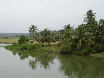
Holegadde near Honavar,Uttara Kannada dist, Karnataka
Copy? Right - but kindly remember to acknowledge!

" tulu-research.blogspot." ತುಳು ರಿಸರ್ಚ್. ಬ್ಲಾಗ್ಸ್ಪಾಟ್. ಇನ್

Have a nice day !